
Sidewalks, crosswalks and curb ramps are vital forms of public, right-of-way transportation for pedestrians, especially for people with disabilities. As such, any pedestrian facilities need to be safe, accessible and compliant with Federal Transit Administration’s Public Right-of-Way Accessibility Guidelines (PROWAG)—standard requirements for designing, constructing and altering any pedestrian facilities.
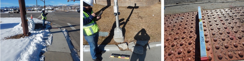
As cities upgrade their ROWs, STV’s accessibility and field practice teams design infrastructure within full compliance of PROWAG requirements and standards implemented by the American with Disabilities Act (ADA). Typically, this process involves walking a city’s entire ROW, pausing to take measurements and images of a sidewalk or curb, uploading that data to our team’s proprietary, cloud-based field application and repeating throughout an entire city. Depending on a city’s size, this process entails a significant amount of time, requiring teams to physically walk hundreds of miles.
To help make this process more efficient and expedient for our clients, STV has partnered with Surface Systems & Instruments (SSI) to pilot its profiler vehicle on our right-of-way (ROW) project with the City of Killeen, TX.
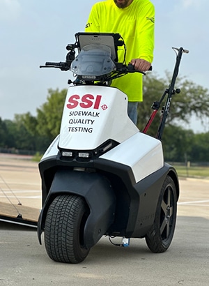
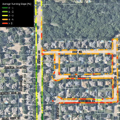
Using a Segway platform, SSI’s profiler is equipped with laser sensors that capture measurements along the path of travel, such as the running slope and cross slope of a sidewalk. These sensors can also identify vertical discontinuities like panel gaps or heaves that form when soil sinks or buckles. Gathering real-time data, the profiler shows us where issues or obstacles are present, geotagging them with an image and location.
STV’s team is currently testing out SSI’s T3 model, the CA 8600 Ultralight Profiler, against manual measurements of the ROW in Killeen. Our firm is a long-time partner of the city, having previously conducted audits of the Killeen’s programs and its website accessibility. STV is now mapping out its 800-plus miles of ROW, assessing sidewalks, signalized intersections, bus stops and curb ramps.
Using our manual method as a control, we’re able to evaluate the profiler’s accuracy and its PROWAG compliance. When combined with our innovative field app and data collection process, we can isolate specific sections of ROW that fail or pass our tests.
SSI’s technology allows us to collect and analyze data in a faster, safer manner. We’ll be able to deliver our assessments more quickly to our clients, providing a more efficient and cost-effective solution. We’re also keeping our staff safer. In Central Texas where our project is based, summer temperatures combined with pavement heat can climb to 120 degrees. The profiler helps us complete field exposure faster and shift the work of data processing to indoors.
Over the next few months, our team will test SSI’s Profiler and determine how we can apply this technology on future projects. As a geospatial manager with over 20 years in the industry, this technology will change our communities to be safer and more accessible for all.

Chad Hall, P.E., GISP, is the geospatial manager in STV’s Field Practice Management. He leads the Geographic Information System (GIS) group, oversees all sUAS operations, as well as Meeting the Challenge (MTC), an STV Company.